MANILA — More parts of Luzon are now under Tropical Cyclone Wind Signal No. 5 as Super Typhoon Uwan (international name: Fung-wong) continues to intensify while nearing landfall in the Philippines, the Philippine Atmospheric, Geophysical and Astronomical Services Administration (PAGASA) said on Sunday afternoon.
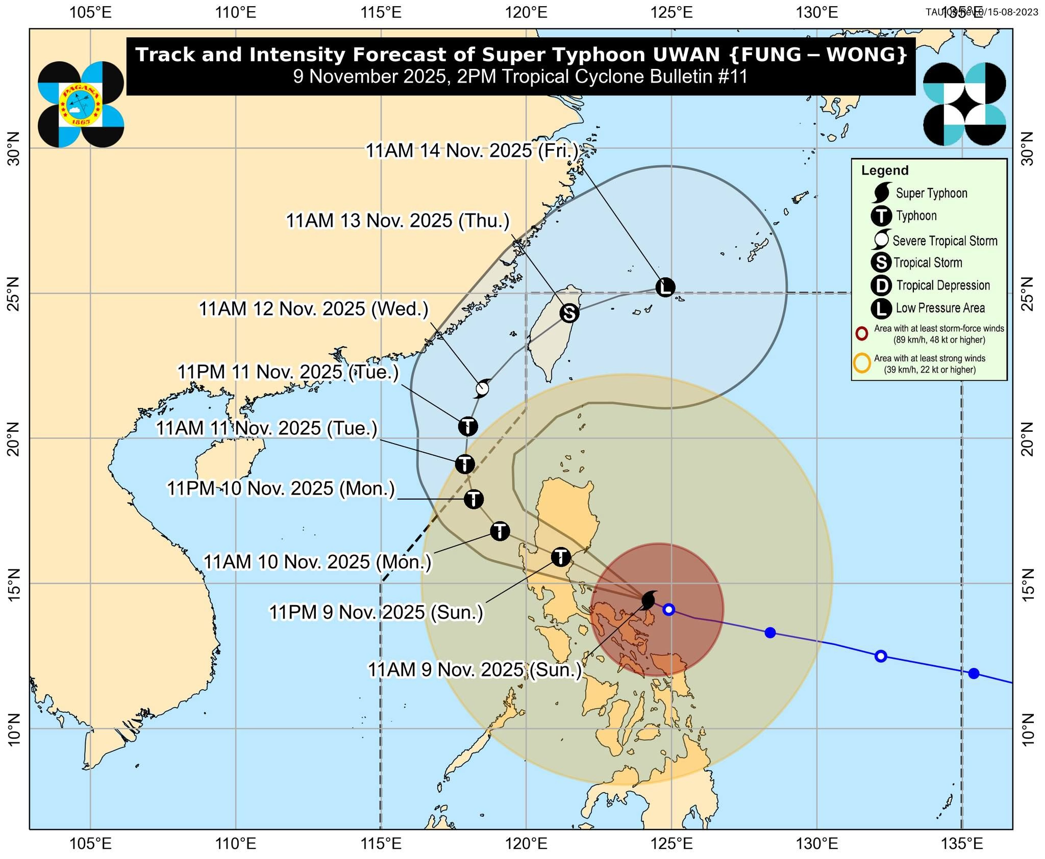
As of 1:00 p.m., Uwan was located 100 kilometers northeast of Daet, Camarines Norte, with maximum sustained winds of 185 kilometers per hour and gusts of up to 230 km/h, moving west-northwest at 30 km/h.
According to PAGASA, Uwan will pass close to Calaguas and Polillo Islands this Sunday afternoon before making landfall over central Aurora on Sunday night or early Monday morning at or near peak intensity. The storm is forecast to weaken into a typhoon as it crosses the mountainous terrain of Northern Luzon before emerging over the West Philippine Sea by Monday morning.
It is expected to temporarily exit the Philippine Area of Responsibility (PAR) on Tuesday, re-enter on Thursday, and then rapidly weaken into a remnant low near the Ryukyu Islands.
Wind Signal No. 5 Areas:
-
Southern portion of Quirino
-
Southeastern portion of Nueva Vizcaya
-
Northeastern portion of Nueva Ecija
-
Central portion of Aurora
-
Polillo Islands
-
Northern portion of Camarines Norte
-
Northern and eastern portions of Camarines Sur
-
Northern portion of Catanduanes
Wind Signal No. 4 Areas:
-
Southern portion of Isabela
-
Rest of Quirino and Nueva Vizcaya
-
Southern Ifugao
-
Benguet
-
Southern Ilocos Sur, La Union, Pangasinan
-
Rest of Aurora, Nueva Ecija, and northernmost Zambales
-
Northeastern Tarlac, eastern Pampanga, and Bulacan
-
Northern and eastern Quezon
-
Rest of Camarines Norte and Camarines Sur
-
Northeastern Albay and rest of Catanduanes
Wind Signal No. 3 Areas (including Metro Manila):
-
Southern Cagayan, rest of Isabela, Apayao, Abra, Kalinga, Mountain Province, Ifugao
-
Southern Ilocos Norte, rest of Ilocos Sur, Zambales, Bataan, Tarlac, Pampanga, Metro Manila, Cavite, Batangas, Rizal, Laguna, Quezon, Marinduque, Albay, Sorsogon, Ticao, and Burias Islands
Preparations and Impact:
Nearly one million people have been evacuated from high-risk areas across Luzon ahead of Uwan’s landfall.
The super typhoon comes just days after Typhoon Tino ravaged parts of the Visayas and Mindanao.
With a massive circulation radius spanning much of the Philippines, Uwan is expected to bring destructive winds and torrential rains across wide areas.
The government has suspended classes and work in public offices for Monday across Luzon, including Metro Manila, where nearly 300 flights have already been canceled.
In Catanduanes, one of the areas forecast to take a “direct hit”, storm surges have sent waves crashing into coastal streets, while floodwaters are rising in several towns.
Government meteorologists warned that up to 200 millimeters (eight inches) or more of rain could fall in many areas, raising the risk of widespread flooding and landslides.
Authorities urged the public to stay indoors, heed evacuation orders, and continuously monitor official weather updates from PAGASA and local disaster agencies.