MANILA, Philippines — October 19, 2025
The Philippine Atmospheric, Geophysical and Astronomical Services Administration (PAGASA) has placed several areas in Luzon — including parts of Metro Manila — under Tropical Cyclone Wind Signal (TCWS) No. 2 on Sunday morning as Tropical Storm Ramil continues to move across the country.
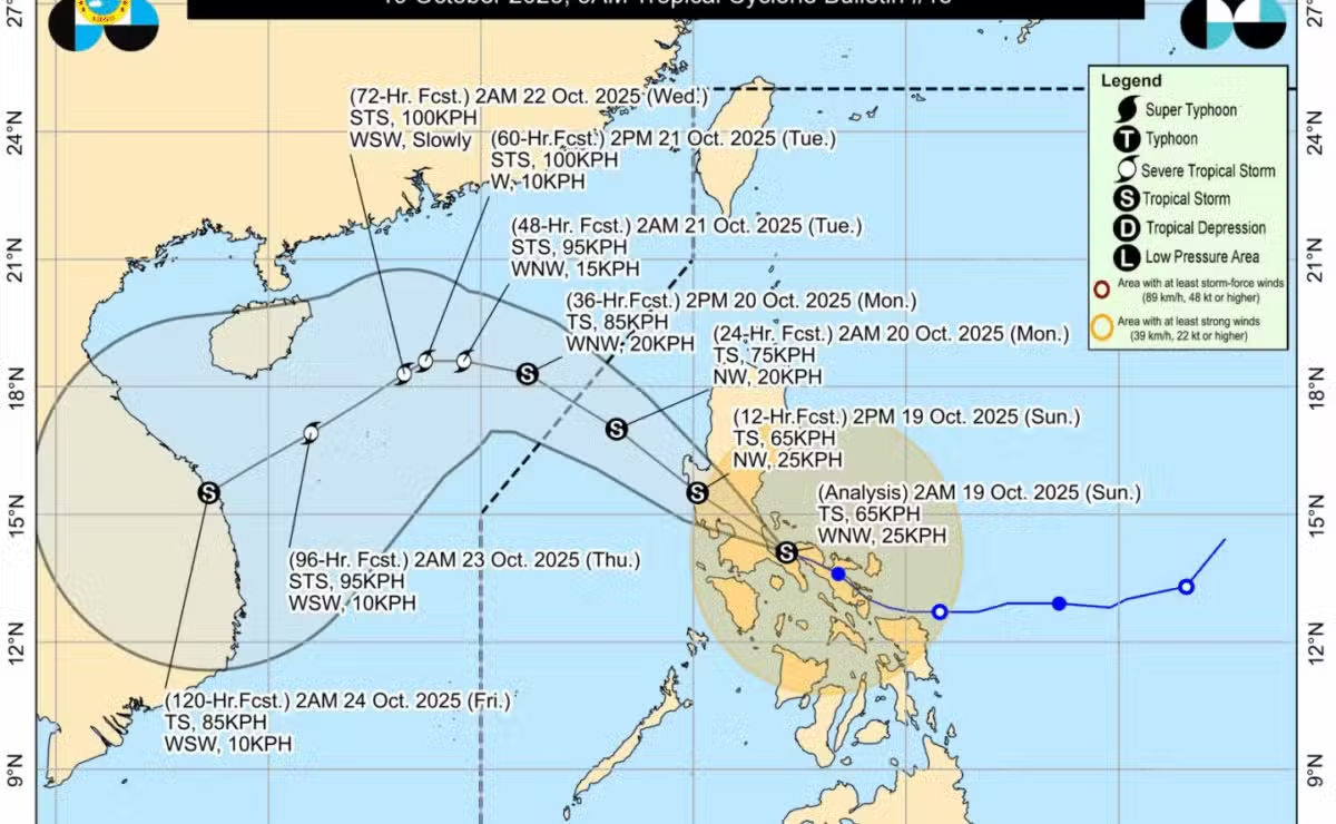
According to PAGASA’s 11 a.m. bulletin, Ramil was last located over Lopez Bay in Alabat, Quezon, moving west-northwestward at 25 kilometers per hour (kph). The stormhas maximum sustained winds of 65 kph near the center and gustiness of up to 90 kph.
Areas Under TCWS No. 2
Luzon
-
Southeastern portion of Quirino
-
Central and southern portions of Nueva Vizcaya
-
Central and southern portions of Benguet
-
Central and southern portions of La Union
-
Pangasinan
-
Aurora
-
Nueva Ecija
-
Bulacan
-
Tarlac
-
Pampanga
-
Northern and central portions of Zambales
-
Northern portion of Metro Manila (Caloocan City, Quezon City, Valenzuela, Marikina, Malabon, Navotas)
-
Northern and central portions of Rizal
-
Northern portion of Laguna
-
Northern and eastern portions of Quezon, including Polillo Islands
-
Camarines Norte
-
Northwestern portion of Camarines Sur
Visayas
-
Northern Samar
-
Northern portions of Eastern Samar and Samar
Areas Under TCWS No. 1
-
The remaining portions of Cagayan (including Babuyan Islands)
-
Isabela
-
Remaining portions of Quirino and Nueva Vizcaya
-
Apayao, Abra, Kalinga, Mountain Province, Ifugao, and the rest of Benguet
-
Ilocos Norte, Ilocos Sur, and the rest of La Union and Zambales
-
Bataan, the rest of Metro Manila, Quezon, Rizal, Laguna, Cavite, and Batangas
-
Occidental Mindoro (including Lubang Islands) and Oriental Mindoro
-
Marinduque, Romblon, Albay, Sorsogon, and the rest of Camarines Sur
-
Northern and central portions of Masbate, including Ticao and Burias Islands
-
Catanduanes
Forecast Track and Outlook
PAGASA said Tropical Storm Ramil may make landfall in Quezon Province within the day, bringing widespread rains and strong winds across Southern and Central Luzon.
The storm is forecast to cross Luzon and may make a second landfall in Zambales or Bataan by Sunday afternoon or evening before exiting the Philippine Area of Responsibility (PAR) by Monday morning or afternoon.
Residents in affected areas are advised to stay alert for possible flooding and landslides, especially in low-lying and mountainous communities. Fisherfolk and those with small sea vessels are strongly advised not to venture out into the sea due to rough to very rough coastal conditions.